

Understanding the weather conditions that have been linked to ice-crystal icing can help pilots avoid situations that may put airplane engines at risk for power loss and damage.
By Matthew L. Grzych, Meteorologist, Atmospheric Physics and Flight Test Engineering
In a majority of ice-crystal icing engine events, convective weather occurs in a very warm, moist, tropical-like environment.
High-altitude ice crystals in convective weather can cause engine damage and power loss in multiple models of commercial airplanes and engines. (More information about engine power loss in ice crystal conditions can be found in AERO fourth-quarter 2007.)
Pilots typically use the term “icing conditions” to refer to weather conditions usually below 22,000 feet where supercooled liquid droplets form ice on cold airframe surfaces. On the contrary, ice-crystal icing conditions connected to engine power loss are thought to be due to completely frozen ice crystals. When flying near convective weather through ice crystal conditions, pilots have reported a lack of airframe icing or ice detection (no supercooled liquid present), but they do notice the appearance of rain on the windscreen, sometimes at temperatures too cold for liquid water to exist. It has been confirmed that the appearance of rain is caused by small ice particles melting on impact with the heated windscreen. Pilots also have noted that the sound made by flight through ice crystals is different from the sound they hear when flying through rain. Although it’s not present on all airplanes, a total air temperature (TAT) anomaly also has occurred simultaneously during some engine events.
The TAT anomaly is due to ice crystals building up in the area in which the sensing element resides, where they are partly melted by the heater, causing a 0 degrees C reading. This phenomenon seems to depend on where the TAT sensor is installed on the fuselage. In some cases, TAT has stabilized at 0 degrees C during a descent and may be noticeable to pilots. In other cases, the error is more subtle and not a reliable-enough indicator to provide early warning to pilots of high concentrations of ice crystals.
This article provides detailed information about the convective weather associated with engine-power-loss events and recommendations on how to increase pilots’ awareness of this weather and help them avoid conditions that can result in power loss.
Overview of engine events associated with convective ice crystals
Engine-power-loss and -damage events are being reported within anvil cloud regions of convective storms at high altitudes. The engines in all events have recovered to normal thrust response quickly.
It has been accepted that ice crystals are the primary source of the engine icing because of the lack of airframe icing reports, lack of radar reflectivity, and the fact that many of these events are occurring at extremely cold temperatures where only frozen particles can exist.
There appear to be certain environments and particular regions within each storm system that most often lead to engine events. The most common observations during these events include:
- The airplane is traversing a convective anvil cloud.
- Pilots are avoiding heavy radar return regions at flight level by 20 miles or more.
- Only light to moderate turbulence is reported leading up to and during the engine events.
- No hail is reported.
- There is no lightning.
- Either a lack of airplane weather radar returns or light radar returns present at flight level.
- Moderate to heavy precipitation (amber or red radar returns) is located below the airplane and the freezing level.
Weather associated with ice crystal engine events
Because it is believed that the clouds where engine events occur are composed of high concentrations of small ice crystals, scientists and meteorologists refer to these as regions of high ice water content (HIWC). Engine events associated with HIWC have occurred in two distinct types of cloud: classic convection and nonclassic HIWC-producing convection (referred to as nonclassic convection from here forward). Roughly 20 percent of engine events occur in classic convection, while the remaining 80 percent occur in nonclassic convection.
Classic convection: Classic convection has vigorous updrafts, is typically found over land, and will have moderate to heavy radar signatures present up to high altitudes, making the core areas and danger zones detectible so the flight crew can avoid them (see fig. 1). Because this region of convective weather can be detected by the airplane’s radar system, pilots can avoid the cell by diverting to the upwind side. In these more typical convective clouds, engine events have been recorded in the anvil cloud downwind from the cell’s core. In the anvil, even though there can be HIWC, ice particles return only enough radar energy to occasionally record green signatures on the pilot’s radar. At other times, there may be no radar returns at all.
Figure 1: Classic convection: Cores readily detectable by radar
This image depicts a vertical cross-section view as an airplane is headed for a classic convective cell. Colors represent standard airplane radar returns where green is light, amber is moderate, and red is heavy. In this scenario, the radar beam pointed straight ahead detects heavy precipitation and the airplane diverts and avoids the weather. There is, however, an area of high ice water content (HIWC) possible in the anvil cloud downwind from the convective core that pilots need to be aware of and avoid.
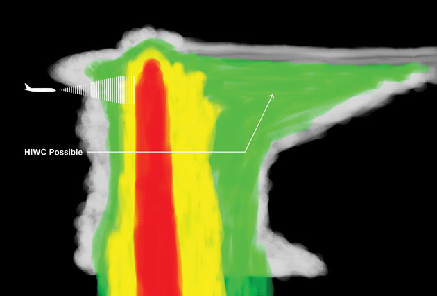
Pilots should avoid the region of anvil cloud downwind from heavy cores near these typical convective cells, especially if light radar returns are present at high altitudes. However, in the majority of ice crystal engine events, pilots unknowingly pass directly over heavy convective precipitation through the anvil cloud into regions of high ice content within nonclassic convective cells, as discussed in the next section.
Nonclassic convection: The type of weather that is most associated with ice crystal icing and subsequent engine events is not what is generally considered typical convection, which has vigorous cores that can be detected at flight level. Instead, the convective weather that is of greatest concern is associated with nonclassic convective clouds that have weak updrafts, regions of decaying convection, and regions of HIWC aloft, but lacks reflectivity at flight level, making it more difficult for pilots to identify (see fig. 2).
Figure 2: Radar view of typical ice crystal engine conditions
This image depicts a cross-section view as an airplane is headed for a nonclassic convective system. During a typical ice crystal engine event, the airplane will be flying in convective cloud with light radar returns at flight level. However, if the pilot uses the radar tilt function to scan below the airplane, moderate to heavy radar returns will be seen. These are regions to avoid because they are associated with regions of HIWC.
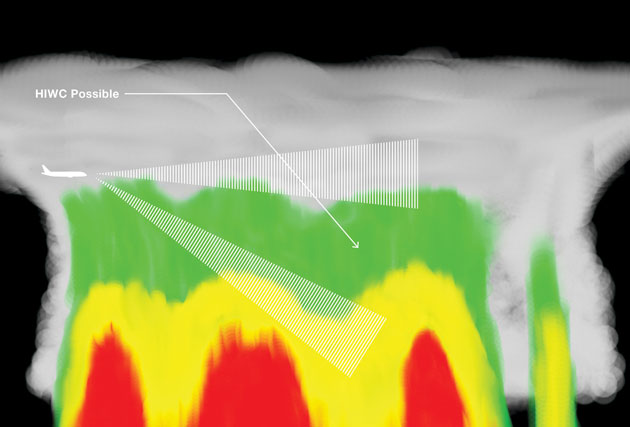
Many times areas of HIWC may be associated with residual areas of merging and decaying cell updrafts within a larger convective system. HIWC regions are typically characterized by relatively weak updrafts that are not strong enough to loft large ice particles, such as hail, to high altitudes, but are able to loft high concentrations of small ice particles up to the tropopause (tropopause height varies depending on the latitude and the season). Large ice particles, such as hail or graupel, are effective radar reflectors and show up on weather radar readily. However, radar returns are not reported during ice crystal engine events, leading meteorologists to conclude that only small ice particles can be present during these events.
Ice crystal engine event: a case study
Airlines can gain valuable insights into convective weather associated with engine power loss and damage by examining an actual engine icing event (see fig. 3). In the enhanced infrared satellite image of a large convective system where an engine icing event occurred, the colored areas represent regions of deep convection and the bright white region is where cloud tops have penetrated through the tropopause into the lower stratosphere. The airplane flew along the path from right to left, entering a large anvil cloud associated with a tropical convective system. A TAT anomaly was observed shortly after the airplane entered the anvil cloud, followed by a series of engine events as the airplane penetrated the deepest part of the storm at temperatures well below freezing. The engines recovered quickly, and the airplane continued safely to its destination.
Figure 3: Infrared satellite image of a large convective system where an engine icing event occurred
This satellite image shows a typical scenario for ice crystal engine events in which an airplane enters a large convective system while on ascent or descent at temperatures well below freezing.
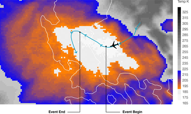
In this region of the convective system, large amounts of moisture are lifted, converted to ice crystals, and then lofted to high altitudes. This event represents a fairly typical scenario for ice crystal engine events in which an airplane enters a large tropical-like convective system while on ascent or descent at temperatures well below freezing. The engine event then occurs while passing through a region of deep glaciated convective cloud with moderate to heavy rain below the airplane.
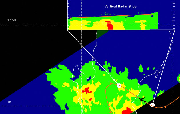
Radar data provides another view of this ice crystal engine event (see fig. 4). The red arrow represents the airplane’s flight trajectory; a series of engine events occurred between the white dots. Low-level radar returns along the path were mostly moderate with some embedded heavy return regions. However, at flight level — where the series of events occurred — radar returns were only scattered light return (green) areas. Using the radar’s tilt function to scan below the airplane would have revealed moderate to heavy returns below.
Figure 4: Satellite-based radar view of convective system where an engine icing event occurred
Radar data for this event shows a top-down view (main image) and a vertical slice looking northeast through the storm (inset). The red arrow depicts the airplane flight trajectory.
Characteristics of systems with areas of high ice content
Although the exact physics and dynamics that contribute to ice crystal engine events are not completely understood, there are many similarities among events.
For example, a majority of the events has occurred in tropical and subtropical regions of the world (usually between 30 degrees south and 30 degrees north latitude). In these cases, the airplane penetrated into the deepest part of a nonclassic convective system, flying directly over heavy rain in the glaciated cloud above.
Nonclassic convection events have also occurred at higher latitudes during summer months; for example, they have been reported in the eastern United States and Japan.
A smaller percentage of engine events, on the order of 20 percent or less, has occurred in classic convection. These events typically occur in mid-latitude, continental storms as an airplane diverts from a heavy weather core at altitude and flies into a region of HIWC adjacent to or downwind of the core.
A conceptual model helps illustrate where areas of high ice content might be found (see fig. 5). In these systems, there can be several areas of active convection where heavy returns may be present to high altitudes, as well as broad regions of decaying convection and moderate to heavy stratiform precipitation regions at lower levels.
Figure 5: Conceptual model showing areas of high ice content
An infrared satellite image of a tropical mesoscale convective system where an engine event occurred (top) and an idealized east-west vertical cross-section through the storm’s center viewing it from south looking north (bottom). Green, yellow, and red areas represent light, moderate, and heavy radar return regions, respectively. Ice content is labeled HIWC.
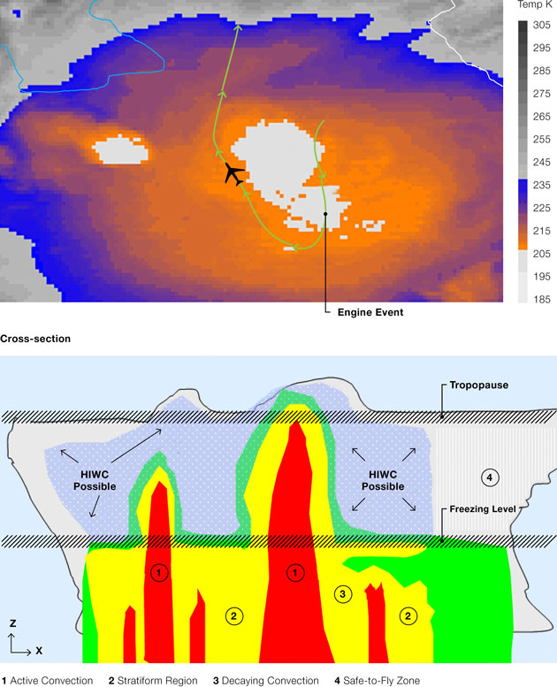
Engine event threat areas include regions above the freezing level either adjacent to or downwind of heavy convective cores or above moderate to heavy rain associated with decaying convection or stratiform regions within the convective system. Both regions are labeled “HIWC Possible” in figure 5.
From an observer’s perspective at high altitudes, the anvil region may grow so large that it can take on the appearance of a thick cirrus cloud shield and lose its visual convective qualities. Essentially, many individual convective cells and their associated anvil clouds all merge into one large, broad system and each individual anvil cloud loses its identity.
Engine events most commonly occur at altitudes of 20,000 to 35,000 feet at temperatures ranging from ‑10 degrees C to -40 degrees C. However, some outlier events have occurred at altitudes as low as 9,000 feet with a temperature of ‑8 degrees C and at altitudes as high as 41,000 feet with temperatures down to ‑63 degrees C.
In a majority of the ice crystal engine events, convective weather occurs in a very warm, moist, tropical-like environment. The atmosphere is generally slightly to moderately unstable, resulting in weak to modest updraft strength. During engine events, pilots report only light to moderate turbulence. These convective systems are generally large, heavy rain producing storms that have life cycles ranging from several hours to 24 hours or more.
Typically, events do not occur in severe convection with strong updrafts because these cells are detectable at altitude, and pilots are able to avoid them. However, in some cases high concentrations of ice crystals can be present within the anvils of these storms either adjacent to or downwind from heavy cores.
Recommended actions
Based on an analysis of the ice crystal engine event database, Boeing has developed the following recommendations to help flight crews avoid regions of HIWC:
- During flight in instrument meteorological conditions (IMC), avoid flying directly above significant amber- or red-depicted map weather radar regions.
- Use the weather radar gain and tilt functions to assess weather radar reflectivity below the airplane.
For example, if an airplane is flying in IMC above the freezing level and there are amber or red radar returns in the vicinity or cloud tops up to the tropopause, or the airplane is known to be in a convective cloud, regions of HIWC may be in the area. In this scenario, the pilot should point the radar down to look below the freezing level. If amber and red areas indicating heavy rain are detected below the freezing level, HIWC areas are possible above these low-level moderate to heavy rain regions. Under these conditions, the pilot should consider evasive action.
Summary
To date, the engines affected in all recorded ice crystal events have recovered to normal thrust response quickly. However, due to the possibility of continued power loss and the risk of engine damage, airlines can use this information to help them avoid flying in convective weather associated with engine-power-loss events.
For more information, contact Matthew Grzych.

Recognize areas where ice crystals may exist.
- Above the freezing level in convective weather.
- Near the deepest part of a convective cloud.
Recognize common conditions.
- Moderate to heavy rain is present below the airplane, producing amber and red radar returns, but little or no returns at flight level.
- Weak to modest updraft velocities.
- Light to moderate turbulence.
Operating instructions.
- During flight in instrument meteorological conditions, avoid flying directly above significant amber or red radar returns.
- Use the weather radar gain and tilt functions to assess weather radar reflectivity.

Convective weather, or atmospheric convection, is the result of an unstable atmosphere where ascending air parcels condense moisture to high altitudes sometimes resulting in one or more of the following:
- Vertically deep cloud with a large cirrus (anvil) region.
- Areas of strong wind shear and turbulence.
- Lightning.
- Areas of high condensed-water content.
- Heavy precipitation and hail.
- Regions of highly concentrated ice particles.

