

Benefits such as improved safety margins, reduced pilot workload, and greater operating efficiency are driving the aviation industry’s move from primarily paper-based navigation charts to fully digital charting technology. While worldwide digital terminal charts have been available in electronic flight bags (EFBs) for some time, recently released data-driven en route charting is the first step in moving to an entirely new charting technology. Future applications are expected to extend data-driven technology from gate to gate, and include valuable, up-to-the-minute flight information onto charts, providing more complete and timely situational awareness to the pilot.
By Rick Ellerbrock, Director, Aviation Strategy, Jeppesen, and
Skip Haffner, Manager, Global Strategic Relationships, Jeppesen
Real-time route planning streamlines onboard operations, reduces fuel burn and delays, and improves on-time performance.
More and more airlines are using EFBs to enhance the accuracy and efficiency of flight deck operations. Boeing and its subsidiary Jeppesen currently provide a number of applications for all EFB classes, including airport moving map (AMM), en route and terminal charting, onboard performance tool, video surveillance, and document browser. Included in Jeppesen’s charting application is an en route dynamic, seamless worldwide visual representation of en route chart data during flight, updated to keep pace with the airplane’s location and overlaid with the planned route of flight.
The next step in creating a completely digital flight deck will be adding real-time geo-referenced information and extending data-driven technology beyond the en route phase of flight.
This article provides details about the currently available data-driven en route charting solutions, along with an overview of developing technologies that will contribute to further enhancing safety margins and operational efficiencies in the future.
Replacing paper charts on the flight deck
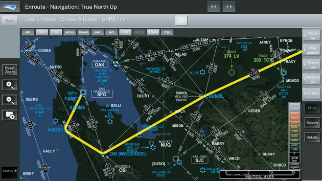
A data-driven, en route charting application, such as that currently offered by Jeppesen, can not only eliminate the need for cumbersome paper en route charts but also provide operators with real-time route planning capabilities and global positioning system (GPS)-based positional awareness in-flight. Jeppesen’s EFB digital data-driven en route charting application was recently determined by the U.S. Federal Aviation Administration (FAA) to be suitable as an in-flight paper chart replacement (see fig. 1). The digital data-driven en route charting application uses real-time GPS data to enable accurate route planning and on-ground positional awareness.
Figure 1: Data-driven en route charting application
En route data-driven charting includes a variety of information, including airports, airways, waypoints, navigational aids, airspace, and terrain information, and thousands of regional and operational notes that enable the elimination of traditional paper charts. The solution is available on a number of platforms, including the Boeing electronic flight bag (EFB).
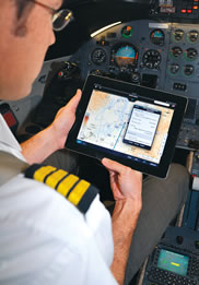
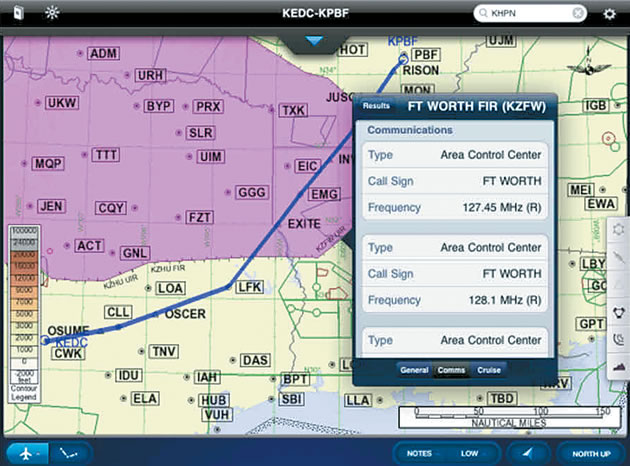
An FAA authorized version of Jeppesen charting for iPad is also available (see fig. 2). iPad gained rapid, unprecedented popularity as an EFB in all aviation market segments. Jeppesen’s charting app gained initial FAA authorization with Executive Jet Management in February 2011. In December, American Airlines became the first airline to receive FAA authorization to use Jeppesen charts on iPad during all phases of flight. Many air carriers around the globe are actively evaluating mobile EFB platforms including iPad, with simulator and in-flight evaluations to help develop required operating procedures and training programs, and to validate its use in all phases of flight for paper chart elimination.
Figure 2: Data-driven en route charting on iPad
Jeppesen Mobile FliteDeck for iPad offers a full paper replacement on the device, making it a popular EFB choice.
Data-driven charting offers more flexibility and intelligence than precomposed chart images. It allows the user to activate and deactivate certain functions, apply filters to control presentation, and otherwise manipulate, within predetermined parameters, what is displayed on the chart and how. Being dynamically rendered, data-driven charts enable information readability and usability across a broad range of map scales, a new feature that is not available with en route charts that have fixed presentation, also referred to as “precomposed.” In addition, data-driven charting requires significantly less storage capacity than precomposed images.
Digitally enhanced full-color, high-quality, vector-based data with zoom and pan features allow greater detail to be rendered on the EFB display. The map can be re-rendered with one click to show either low-altitude or high-altitude information, as needed. The search function allows immediate access and display of a needed chart feature, such as an airport, navigational aids, or waypoint. The technology also enables flight crewmembers to more easily collaborate and share information. Pilots can also choose what flight data is displayed, including airports, airways, waypoints, navigational aids, airspace, and terrain information, allowing for an individualized, dynamically rendered on-screen presentation that best supports the task at hand.
AMM improves runway safety
Since 2003, Jeppesen has offered AMM for EFB that dynamically renders high-resolution Jeppesen maps of the airport surface. Through the use of GPS technology, AMM shows pilots their position (“own-ship”) on the airport surface (see fig. 3). The result is significantly improved positional awareness for the pilot, which has led to proven improvements in taxi efficiency, i.e., less fuel burn, and reduction in runway incursions during ground operations, especially at busy airports with complex runway and taxiway layouts.
Figure 3: Airport moving map
An airport moving map, such as this one of Chicago O’Hare airport (ORD), improves positional awareness among flight crews.
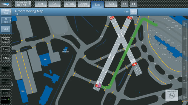
Jeppesen conducted numerous field studies using simulators and airline flight crews to validate the benefit of AMM technology for EFBs. These studies revealed consistent improvement in pilot performance because flight crews are better able to anticipate their location in relationship to runways, taxiways, and parking locations. Additional research by the Commercial Aviation Safety Team estimates that runway incursions caused by pilot deviations could be reduced by as much as 50 percent when flight crews use AMM.
The AMM application is available for Class 2 and Class 3 EFBs.
The future of data-driven charts
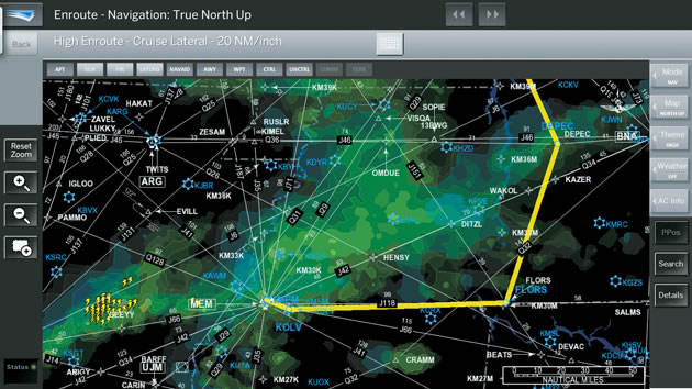
The next step in the evolution of the data-driven en route EFB will be to add enhanced routing functions and highly integrated real-time weather data (see fig. 4).
Figure 4: Weather data on en route navigation chart
Adding weather data to data-driven en route navigation provides flight crews with valuable information at a glance.
The future of advanced information management technologies for navigation includes a flight deck that is connected to the airline operations center with real-time data, integration of ground-based and airborne information systems, and leveraging of the growing data-link capabilities of commercial airplanes.
The next generation of electronic data-driven charting will extend today’s digital charting by providing a seamless gate-to-gate solution. It will also include smart information layers that overlay information such as Notices to Airmen (NOTAMs) and new weather products such as four-dimensional “weather cube” data being developed in support of NextGen.
Traffic overlays using ADS-B technology are also supported in the data-driven framework, providing even more situational awareness and enabling fuel- and time-efficient functions to manage merging and spacing of traffic in the terminal area and in-trail procedures over the ocean. The result will be an integrated flight deck approach that will allow flight crews to view the information they need in a single place, with an airport map or navigation chart as a background layer, whether they’re taxiing from the gate, taking off, cruising, or landing (see fig. 5).
Figure 5: The next generation of digital charting
Future charting technologies will provide flight crews with the information they need from gate to gate, including airport taxi (top), en route navigation (center), and arrival and approach (bottom), all linked seamlessly. The application will display NOTAMs and weather alerts as overlays directly on the chart, providing flight crews with a single view of flight information that improves situational awareness, decision making, and flight efficiency.
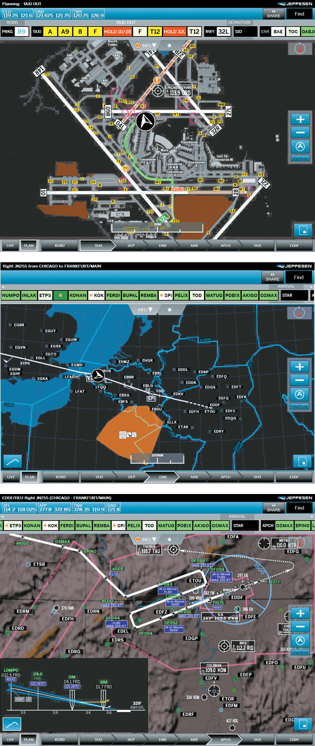
In addition, the system is being designed for context awareness, automatically updating what is depicted onscreen to reflect the current phase of flight. For example, when entering the geometry of an assigned runway and being aligned within a defined tolerance of the bearing of the runway, the system detects the upcoming departure and switches to departure mode, changing the field of view and information content.
Benefits to operators
Data-driven charting applications can help operators improve their safety margins, reduce pilot workload, and increase operational efficiencies.
Safety. The system supports safety objectives by improving situational awareness through the availability of more complete and timely information about the airplane’s navigation, weather, terrain, and traffic situation. AMMs help enable enhanced safety during ground operations.
Reduced workload. By providing flight crews with charting and other relevant flight information in one place, the system eliminates the need to carry and sort through large amounts of unlinked printed information.
Operational efficiency. Replacing paper charts, providing operators with real-time route planning capabilities, and delivering intelligent information when and where it’s needed will help streamline onboard operations, reduce fuel burn, reduce delays, and improve on-time performance.
Summary
Jeppesen offers a variety of EFB-based digital charting applications, including iPad applications. It is also developing ways to display real-time flight information, such as NOTAMs and ground-based weather forecasts, for display on digital navigation charts.
For more information, please contact Airline Services at Jeppesen.