

Volcanoes continue to erupt around the world, from Iceland to Ecuador and from Chile to Africa, causing disruption to air travel. Airspace monitoring and flight operational procedures have been put in place and commercial jet aviation has been operating safely in areas with volcanic eruptions. Boeing’s recommendation is to avoid areas of visible ash. However, if a flight crew inadvertently encounters volcanic ash, there are steps that they can take to safely exit the ash cloud. Additional efforts are being made to improve the efficiency of air traffic in the event of a volcanic eruption.
By Douglas Kihm, Technical Fellow, Airworthiness and Extended Operations,
and Darren Macer, Lead Engineer, Boeing Commercial Airplanes Operations Center
In regions with volcanic activity, airline operations can be safely conducted by following fundamental guidelines.
Since the significant Eyjafjallajökull volcanic event of 2010, the aviation industry has developed additional guidance for safe, efficient flight operations in the event of a volcanic eruption. The International Civil Aviation Organization (ICAO) International Volcanic Ash Task Force (IVATF) is leading this effort. The industry is accumulating and reviewing the world’s best practices for addressing airspace control during a volcanic eruption and developing recommendations that accommodate all global situations. Boeing provides significant support to this effort.
This article details ongoing work to improve the efficiency of air traffic in the event of a volcanic eruption, provides information about operating in the vicinity of a volcanic ash cloud, explains how to detect the presence of a volcanic ash cloud, and offers practical information for flight crew operations and maintenance inspections if a volcanic ash cloud is encountered.
Monitoring and responding to volcanic ash events
Although some information about volcanic eruptions had been available at the time of eruptions in the 1980s and 1990s, the aviation industry recognized that it was insufficient. The industry then collaborated with the volcanological and meteorological communities in a joint effort to find ways to avoid future volcanic ash encounters.
ICAO has laid much of the foundation for volcanic ash monitoring through its Volcanic Ash Warnings Study Group. ICAO also formed the International Airways Volcano Watch Operations Group in 1987. These groups formalized the international arrangements for monitoring and providing warnings to the aviation community about volcanic ash in the atmosphere.
ICAO’s Annex 3 Meteorological Service for International Air Navigation and the World Meteorological Organization’s Technical Regulation C.3.1 introduced standards to disseminate information about volcanic ash to the aviation community in the form of Significant Meteorological Information (SIGMET) and Notices to Airmen (NOTAM).
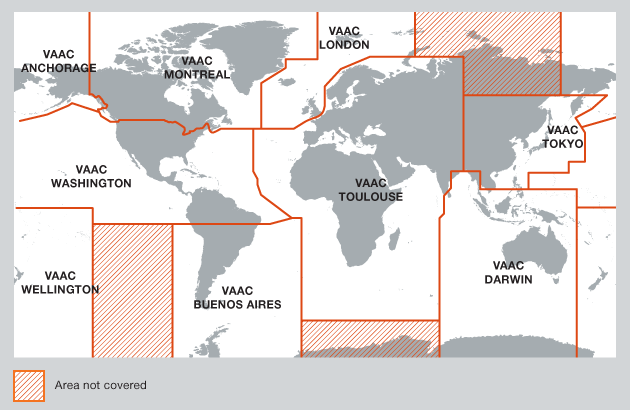
One of the results of these efforts was the establishment of today’s Volcanic Ash Advisory Centers (VAACs). VAACs provide an important link among volcano observatories, meteorological agencies, air-traffic control centers, pilots, and operators. Currently, nine VAACs continuously monitor and report on a particular region of the world (see fig. 1).
Figure 1: Volcanic Ash Advisory Centers
There are nine Volcanic Ash Advisory Centers (VAACs) located around the world. Each VAAC focuses on a specific geographical region.
ICAO has also published the Handbook on the International Airways Volcanic Watch (Document 9766). It defines responsibility and operational procedures for distributing information on volcanic eruptions and associated ash clouds that could affect routes used by international flights.
Improving operational efficiency during volcanic ash events
Commercial jet aviation has been operating safely and efficiently for many years since the hazards associated with operations in volcanic ash have been identified and airspace and flight operational procedures have been established. This successful history has been based on avoiding operations in a visible ash cloud or one discernable by satellite imagery, ground observers, flight crew, and pilot reports, augmented by forecasting model predictions and SIGMETs as required.
In most of the world, flight operations in the event of a volcanic eruption have been based on information provided by the VAAC to airlines about the location and forecasted movement of the visible ash cloud. The calculated ash concentration values produced by trajectory/dispersal models are strongly dependent on the input values of the models — including the total amount, composition, height of the plume, and particle size of ash being ejected from the volcano. Input values are difficult to estimate, which leads to inaccuracies in the forecasted concentration charts. These inaccuracies can vary from one eruption to another, even from the same volcano. As a result, trajectory/dispersal model forecasts need to be correlated with other observations. For the 2010 Eyjafjallajökull event, the areas where high ash concentration was forecasted appear to correlate roughly to areas of visible ash as seen from satellite images.
In the aftermath of the Eyjafjallajökull eruption, ICAO’s European and North Atlantic (EUR/NAT) Office revised the existing EUR/NAT volcanic ash contingency plan. A key enhancement was the decision to control airspace as is done by other airspace control authorities: After an initial eruption, the volcanic ash cloud is treated like a meteorological event and advisory and SIGMET information is provided to operators to allow them to determine how best to avoid operations in the volcanic ash cloud (see fig. 2). This approach proved successful in other areas of the world.
Figure 2: 2009 Mt. Redoubt Volcanic Ash Advisory
This Volcanic Ash Advisory graphic from the 2009 Mt. Redoubt eruption was created using satellite imagery, ground observers, flight crew, pilot reports (PIREPs), and forecasting models.
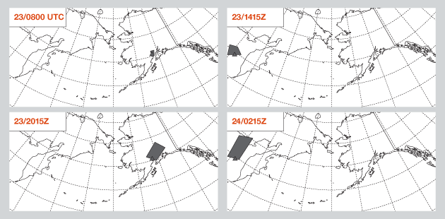
| VOLCANIC ASH ADVISORY DTG: 20090326/2040 VAAC: ANCHORAGE AREA: SOUTH CENTRAL ALASKA SUMMIT ELEV: 10198FT (3109m) ADVISORY NUM: 2009–18 |
INFO SOURCE: POES/GOES/AVO/PILOT REPORT/RADAR ERUPTION DETAILS: EXPLOSIVE ERUPTION AT 26/1724 UTC REMARKS: LIGHT ASHFALL REPORTED AT HOMER BY TRUSTED OBSERVER. NEXT ADVISORY: 20090327/0240Z |
ICAO’s IVATF is currently working to consolidate successful practices from around the world to provide enhanced volcanic ash contingency procedures and improve the accuracy and consistency of the VAAC advisories.
Boeing supports efforts to continue to understand the susceptibility of airplanes and jet engines to volcanic ash clouds. Because of the unique characteristics of each volcanic eruption and the ensuing ash cloud, it is not practical to define a single ash concentration threshold for airplanes or jet engines. Boeing continues to recommend avoiding visible ash and is also working with the aviation community through the ICAO IVATF to refine and enhance ICAO’s volcanic ash regional contingency plans.

The term “visible ash” is used by Boeing to refer to various situations where ash can be seen visually or observed. Although the term is somewhat ambiguous, visible ash has been used successfully to describe areas where flight planners should avoid scheduling flights and flight crews should avoid flight operations. From a flight-crew perspective, visible ash is ash that can be seen by looking out the windows or observed in other ways, such as electrostatic discharge on the airplane exterior or haze in the flight deck. Boeing’s recommendation to operators to avoid operations in visible ash also relies on observations by Volcanic Ash Advisory Centers (VAACs) to define a volcanic ash cloud location and its forecasted movement. The VAACs use methods such as visual examination of satellite imagery, either visible or infrared, to discern where a volcanic ash cloud is located. This VAAC-observed volcanic ash cloud information is also used to develop the volcanic ash Significant Meteorological Information, which is used by operators to avoid the visible volcanic ash cloud.
Airline Flight Planning to avoid volcanic ash
Airline flight planning staffs and flight crews should be aware of potential volcano eruptions near their routes. One way is through aviation color-code notifications (see fig. 3). These notifications are used to provide succinct information about volcanic ash hazards to the aviation industry. The color codes are in accordance with recommended ICAO procedures to help pilots, dispatchers, and air traffic controllers who are planning or executing flights over broad regions of the globe quickly ascertain the status of numerous volcanoes. They can use this information to determine whether continued attention, flight rerouting, cancellation, diversion, or extra fuel is warranted.
Figure 3: Aviation color-code notifications
Aviation color-code notifications provide concise information about potential volcanic ash hazards. Airline flight planners can use this information to route flights away from potential ash clouds.
| Green Alert | Yellow Alert | Orange Alert | Red Alert | ||||||
Volcano is in normal, non-eruptive state. Or, after a change from a higher alert level: Volcanic activity considered to have ceased and volcano returned to its normal, non-eruptive state. |
Volcano is experiencing signs of elevated unrest above known background levels. Or, after a change from higher alert level: Volcanic activity has decreased significantly but continues to be closely monitored for possible renewed increase. |
Volcano is exhibiting heightened unrest with increased likelihood of eruption. Or: Volcanic eruption is under way with no or minor ash emission (specify ash-plume height if possible). |
Eruption is forecasted to be imminent with significant emission of ash into the atmosphere likely. Or: Eruption is under way with significant emission of ash into the atmosphere (specify ash-plume height if possible). |
||||||
| Note: The color code for the level of alert indicating the status of activity of the volcano and any change from a previous status of activity should be provided to the area control center by the responsible volcanological agency in the state concerned (e.g., “Red alert following yellow” or “Green alert following orange”). | |||||||||

Several past volcanic ash events have resulted in either significant damage to jet-powered commercial airplanes or caused significant disruption to air traffic:
- Eyjafjallajökull, Iceland, 2010. The eruption’s ash plume drifted eastward, reaching as far as the United Kingdom and parts of Western Europe. Air travel over western and northern Europe was disrupted for six days because of the amount of ash ejected into the atmosphere and the forecast that the ash would reach some areas of very high air traffic volume. The contingency plans and procedures for airspace control during this event were not adequately defined or understood, resulting in significant disruption to European and North Atlantic air traffic.
- Mt. Pinatubo, Philippines, 1991. More than 20 volcanic ash encounters occurred after the Mt. Pinatubo eruption, which was one of the largest volcanic eruptions of the past 50 years. Commercial flights and various military operations were affected; one U.S. operator grounded its airplanes in Manila for several days.
- Mt. Redoubt, United States, 1989. On a flight from Amsterdam to Anchorage, Alaska, a 747-400 encountered an ash cloud from the erupting Mt. Redoubt near Anchorage. All four engines ingested ash and subsequently flamed out. The crew successfully restarted the engines and landed safely at Anchorage. All four engines were replaced, and many airplane systems also had to be repaired or replaced before the airplane was returned to service.
- Galunggung, Indonesia, 1982. Several 747 airplanes encountered ash from this eruption. One airplane lost thrust from all four engines and descended from 36,000 feet to 12,500 feet before all four engines were restarted. That airplane, on a flight from Kuala Lumpur, Malaysia, to Perth, Australia, diverted to Jakarta and landed safely despite major engine damage. The airplane subsequently had all four engines replaced before returning to service.
- Mt. Saint Helens, United States, 1980. A 727 and a DC-8 encountered separate ash clouds during this major eruption. Both airplanes experienced damage to their windshields and to several systems, but both landed safely despite the windshield damage.
Detecting the presence of a volcanic ash cloud
Despite all precautions and planning, it is still possible to encounter an ash cloud. Boeing provides training and instructions for flight crews to use when there is an indication that an airplane has entered an ash cloud, which can be found via the Web portal MyBoeingFleet.com. Discernable indicators that an airplane is penetrating volcanic ash can include odor, haze, changing engine conditions, air speed, pressurization, and static discharges.
Odor. When encountering a volcanic ash cloud, flight crews usually notice a smoky or acrid odor that can smell like electrical smoke, burned dust, or sulfur.
Haze. Most flight crews, as well as cabin crew or passengers, see a haze develop within the airplane. Dust can settle on surfaces.
Changing engine conditions. Surging, torching from the tail pipe, and flameouts can occur. Engine temperatures can change unexpectedly, and a white glow can appear at the engine inlet.
Air speed. If volcanic ash fouls the pitot tubes and static ports, the indicated air speed can decrease or fluctuate erratically, with associated effects on airplane systems.
Pressurization. Cabin pressure can change, including possible loss of cabin pressurization.
Static discharges. An electrostatic phenomenon similar to Saint Elmo’s fire or glow can occur. In these instances, blue-colored sparks can appear to flow up the outside of the windshield or a white glow can appear at the leading edges of the wings or at the front of the engine inlets.
Recommendations for flight crew if a volcanic ash cloud is encountered
If an airplane does encounter a volcanic ash cloud, Boeing provides flight crew procedures for dealing with the situation. The following are general recommendations (each operator’s flight operations manuals include more specific instructions):
- Flight conditions permitting, reduce thrust to idle immediately.
- Turn the autothrottles off.
- Exit the ash cloud as quickly as possible. A 180-degree turn out of the ash cloud, using a descending turn, may be the quickest exit strategy.
- Turn on the engine and wing anti-ice devices.
- Turn on all air-conditioning packs.
- If possible, start the auxiliary power unit.
- If volcanic dust fills the flight deck, the crew may need to use oxygen.
- Turn on the continuous ignition.
- Monitor the engine exhaust gas temperature.
- Fly the airplane by monitoring air speed and pitch attitude.
Following these procedures will ensure the highest possible level of flight safety. Although this information has been available for several years, flight crews need to continue to be vigilant of the signs of volcanic ash and to be familiar with the proper procedures to prevent serious incidents.
Recommendations for maintenance crews if a volcanic ash contamination is reported or suspected
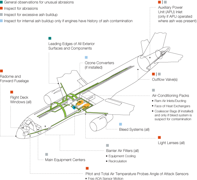
Following a volcanic ash encounter, or suspected encounter, a volcanic ash conditional inspection should be performed as detailed in the Aircraft Maintenance Manual, Chapter 05 (see fig. 4). As a result of the 2010 Eyjafjallajökull event, based on operator feedback Boeing has restructured the inspections to a phased approach. Whereas the previous inspections required extensive and time-consuming inspections after reported operation in an environment that contained volcanic ash, the new approach allows the inspections to cease if no signs of damage or ash exist at certain points in the phased inspections. The initial phase is designed to be conducted at a remote location without the need of specialized tools, thus ensuring that an airplane can quickly be returned to service if no evidence of ash is detected. Only if evidence of ash is found is the operator required to continue to the next phase, each becoming more involved proportionately to the potential damage due to the encounter.
Figure 4: Volcanic ash conditional inspection
This illustration shows airframe and systems areas of particular interest for operations in areas contaminated with volcanic ash.

In support of the International Civil Aviation Organization (ICAO) Annex 3 standards and the Handbook on the International Airways Volcanic Watch procedures, regions of the world have implemented their own regional plans. One example is the U.S. government's interagency plan for volcanic ash events.
This plan coordinates the operations of the Alaska Volcano Observatory, the Federal Aviation Administration (FAA), and the National Weather Service (NWS), among others. The NWS includes the Alaska Aviation Weather Unit (AAWU), which is both a Volcanic Ash Advisory Center (VAAC) and a Meteorological Watch Office (MWO). The AAWU, as an International MWO, issues volcanic eruption and volcanic ash Significant Meteorological Information.
In this plan, the AAWU, acting as the Anchorage VAAC, issues a Volcanic Ash Advisory during an ash event, which provides guidance to the aviation community. The FAA disseminates pilot reports (PIREPs), Notices to Airmen (NOTAM) and current conditions information to the air traffic controllers and Center Weather Service Unit (CWSU) personnel. The AAWU runs forecast models to predict where the discernible ash cloud will be. The forecasts are calibrated against satellite imagery, PIREPs, ground observation, and spotter aircraft. This approach to providing advisory information to operators is similar to how other significant meteorological events are handled, such as hurricanes. The collaborative interagency approach worked very effectively during the 2009 Mt. Redoubt eruption. For example, it helped one major airline operating in the area avoid any significant inflight volcanic ash encounters. (This is not to say, however, that the airline did not have numerous schedule disruptions as a result of the Mt. Redoubt volcanic ash cloud.)
Summary
Boeing believes that operations in regions with volcanic activity can be conducted safely by avoiding visible ash. A volcanic ash event should be treated like a meteorological event, such as a severe weather condition. Operators should be provided advisory information regarding the location of an ash cloud to use in determining the most appropriate action to take, such as rerouting flights, diverting flights to alternate airports, or cancelling flights. If flight crews unexpectedly encounter an ash cloud, they should take appropriate action.
For more information, contact Doug Kihm.